Far fewer homes on Vashon and Maury island will be eligible for a publicly funded yard cleanup program after a new state analysis indicated arsenic contamination in the region is not nearly as extensive as officials originally believed.
The state Department of Ecology announced in 2011 that it would undertake a neighborhood-by-neighborhood sampling effort to find and remove arsenic-laced soil from those areas most contaminated by Asarco’s industrial plume, which cast a shadow over the region for decades.
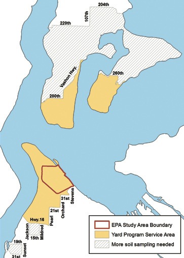
The first iteration of the state’s map included approximately 2,400 residences on the island — all of Maury and the southern half of Vashon as far north as S.W. 204th Street — as well as another 15,000 properties in other parts of the region.
But over the last several months, state officials have worked to create a new version of the map, based on far more data and selected soil samples throughout the region. As a result, only about 720 parcels on Vashon and Maury are now included in the state’s yard program service area — the southern third of Maury Island (a swath that extends as far north as S.W. 260th Street) and the southern tip of Vashon.
Throughout the region, the service area now takes in around 7,000 parcels, down from an initial estimate of 17,000, according to Hannah Aoyagi, an outreach and education specialist in the Ecology Department’s Toxics Cleanup Program.
The first map, she said, “was a pretty rough estimate.” The state’s new analysis, developed by an expert in using geographic data to build statistical models, is far more accurate, she said.
“It’s more focused, and the analysis is a lot more thorough. I think it better reflects what we’re going to find … when we go out and sample,” Aoyagi said.
The new map takes in the area that will now be included in a site-by-site sampling, should property owners agree to have the soil in their yards tested. Based on the sampling and analysis already undertaken, Aoyagi added, she believes only about 100 residences on Vashon — or one in seven — will be over the threshold and eligible for cleanup.
At the same time, she said, the process is an ongoing one, and the state plans to continue to sample areas included in the initial map to ensure every contaminated yard and garden on Vashon gets cleaned up, should the property owner agree.
The island is of particular concern, she added, because it’s heavily wooded and less developed, and arsenic is more likely to be found at high levels in areas that have not been disturbed.
“We want to be more cautious, especially on the island,” Aoyagi said. “We may expand our service area if we find we need to.”
State funding for the massive cleanup comes from a settlement Asarco, a Ruston-based copper smelter, made when it filed for bankruptcy in 2005. The state received $188 million in settlement funds and expects to spend about $64 million of that on its yard cleanup program, the centerpiece of its Tacoma Smelter Plume project.
State officials plan to send letters or knock on doors to get permission to test for arsenic and lead in homeowners’ yards and gardens; they hope to start later this year. Those homeowners with soil that tests high — arsenic at 100 parts per million (ppm), five times above what the state considers clean, and lead at 500 ppm, or twice the state’s cleanup standard — will be offered remediation.
“We don’t know what the participation rate will be. If we don’t get 100 percent participation, we could lower the threshold,” Aoyagi said.
Islanders who have been following the state’s cleanup plan said they were pleased to hear that the state has refined its map. Indeed, many questioned the state’s first map, noting it didn’t match a sampling effort that took place several years ago on the southern portions of the island.
Tom Dean, head of the Vashon-Maury Island Land Trust and a Maury resident, said he’s known for years that “the bull’s eye is really Maury Island, especially those places that are south-facing.”
His home, which he built 13 years ago, remains within the state’s revised service area. He’s already had his soil tested, has amended his soil with compost and other additives and scrubs his vegetables thoroughly, he said. Still, he’ll let state officials onto his property when they’re ready to do neighborhood-by-neighborhood sampling.
“Why not? It’s free,” he said.
Real estate agents, meanwhile, also said they were glad to see the state issue a new map — one that jibes with what they’ve seen and heard over the years.
“I think it’s great news for the island,” said Susan Lofland, an agent with John L. Scott. “The more data points they can collect to really confirm the situation is in all of our best interests.”
Lofland’s property was included in the first map but is not in the newest iteration. “Of course, I’m glad,” she said.
Denise Katz, an agent for Windermere, said she and other agents always disclose information to home-buyers about arsenic contamination on Vashon and Maury, using maps that were issued years ago based on an analysis by the King County health department. She, too, was troubled by the state’s initial map.
“They were just taking the whole area and saying it was impacted,” she said. “I’m glad that they’re actually taking a closer look.”
Meanwhile, the state is issuing its final plan for yard cleanup, outlining the nuts and bolts of the residential program. The plan is posted on the Ecology Department’s website and is available for public comment starting tomorrow through April 29.
The plan is similar to one state officials first unveiled a year and a half ago but also takes into account comments they’ve received since they announced the yard cleanup program. The plan, for instance, makes clear that the state will only clean high-use areas near people’s homes or areas where children might play, not forested areas.
“We’re not in the business of cutting down forests to do a cleanup,” Aoyagi said.
At the same time, she said, state officials plan to test forested areas as well so that property owners know what the levels are and can make decisions for themselves about how to use their property and take care of themselves and their children.
“That was a big issue for us — what we were going to do about places that we can’t clean up,” Aoyagi said.
To comment on the plan
Visit www.ecy.wa.gov/toxics/tacoma-smelter.html to find the state’s “Yard Sampling and Cleanup Program and Design,” a 60-page document now available for public comment. Comments can be sent to Amy Hargrove at the Department of Ecology, PO Box 47775, Olympia, Wash., 98504-7775. Or email her at Amy.Hargrove@ecy.wa.gov.