New signs mark the history beneath Vashon’s roads
Published 1:30 am Tuesday, July 28, 2026
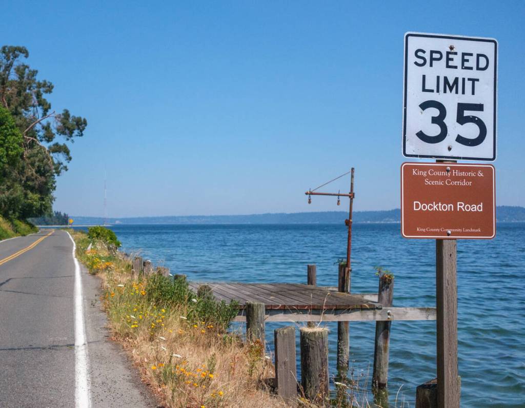

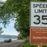
On Dockton Road, where the pavement curves past bright blue water, weathered docks, beaches, farms and woods, a small brown sign has appeared beneath a 35 mph marker.
Its color — reminiscent of signs at national parks and historic sites — announces that islanders are traveling through a King County historic and scenic corridor.
“These corridors aren’t new,” said Tom Minichillo, cultural resources coordinator and archaeologist for the King County Road Services Division. The routes were designated nearly two decades ago, he said, adding: “We’re a little slow in putting the signage up.”
King County recently began installing signs along two island routes recognized as heritage corridors in 2009: Dockton Road and Cedarhurst Road/Westside Highway.
Five signs are planned along the 4.7-mile Dockton Road Heritage Corridor, which runs from Chautauqua Beach Road through Ellisport and Portage to 99th Avenue Southwest in Dockton. Six will mark the 8.2-mile Cedarhurst Road/Westside Highway corridor, stretching from Vashon Highway to Southwest 220th Street.
Dockton Road has connected Ellisport, Portage and Dockton for more than a century, evolving alongside early ferry service, the Martinolich Shipyard and the island’s maritime economy, according to King County’s historic corridor reports. Sections of Westside Highway were built between 1891 and 1923, linking shoreline settlements, farms and docks once served by the Mosquito Fleet.
“Dockton Road was a really good example of the scenic corridor,” Minichillo said, pointing to its unobstructed views of Puget Sound. Cedarhurst, he added, “is really kind of curvy and just follows the landscape.”
Manufacturing and installing signs along nine historic and scenic corridors across King County will cost about $3,000, Minichillo said. The corridors themselves were identified through a separate, federally funded study conducted from about 2007 to 2009.
According to King County, the Historic and Scenic Corridors Project was a collaboration among the county’s Road Services Division, Historic Preservation Program and 4Culture. It was funded through a federal transportation grant administered by the Washington State Department of Transportation.
Researchers used geographic information system data to examine the county’s entire road network, looking for older roads that retained their historic routes, surrounding scenery and concentrations of historic properties.
“The main purpose is to preserve history — to point out places where some of our rural roads still have maintained some of the historic character of when they were first built,” Minichillo said.
Island historian Bruce Haulman said the corridors can also help explain why different parts of Vashon-Maury developed as they did.
“These historic corridors and others like them help tell us the story of how we became who we are, how different parts of the island developed differently, and how it all coalesced into a single community we call Vashon-Maury Island,” Haulman said.
Eight of the nine routes were designated King County Community Landmarks, an honorary status that imposes no restrictions on nearby property owners or businesses.
“It just recognizes the historical importance of something without attaching any regulatory burdens to it,” Minichillo said.
The designation does, however, influence some smaller decisions made by the Roads Division. New guardrails along heritage corridors, for example, may be made of weathering steel or painted brown rather than shiny galvanized metal.
County officials wanted to install signs after completing the original study. But the Federal Highway Administration would not allow the grant money to be used because signage had not been included in the proposal.
Road officials planned to pay for the signs later. Then the economic downturn strained the division’s budget and brought widespread layoffs.
“Doing something like paying out local funds to put out informational signs for this wasn’t on the radar,” Minichillo said. “And then it just kind of slipped away.”
The idea resurfaced this past year after a regional transportation advisory group requested signs, which county crews are adding to existing speed limit posts as they work nearby.
For safety, the signs use minimal text and lettering sized to be read quickly by passing drivers without distracting from the road, Minichillo said.
Dockton Road is the only maritime-themed route in the county’s heritage corridor system. An early 1907 map showed a rudimentary road through the woods between the former Chautauqua grounds near Ellisport and Portage, then an important shipping point and island crossroads.
A waterfront section was completed in 1916 to serve an auto ferry dock on Tramp Harbor. The growth of the Martinolich Shipyard also helped spur the road connection between Portage and Dockton. By 1926, the road largely followed its present-day alignment.
According to the county’s report on the Cedarhurst Road/Westside Highway corridor, the route descends from the island’s crest through the forested Shinglemill Creek watershed before reaching farmland, orchards and western shoreline communities.
Westside Highway was constructed in pieces, sometimes following old logging roads and taking the names of landowners who petitioned for individual sections.
Together, the routes trace what Haulman described as the larger transformation of Vashon from numerous isolated, water-facing communities connected by Mosquito Fleet steamers to a more centralized island community.
Vashon once had 32 steamer docks, 16 post offices, 16 community stores and 13 school districts, Haulman said. Over time, those dispersed communities gave way to two principal ferry docks, one central commercial district, a single school district and one post office.
By the early 20th century, communities including Cedarhurst, Colvos, Cove and Lisabeula had stores, docks and post offices, while nearby farms produced strawberries and orchard fruit and supported poultry and greenhouse operations.
Haulman said the new markers join local efforts such as the Dockton Historic Trail, Ellisport Hidden History Trail and interpretive signs at parks and trailheads that encourage people to look more closely at the places around them.
“The signs themselves are only reminders that there is knowledge, information and understanding to be found if you look,” he said.