
Many on Vashon are familiar with king tides, those extreme high-water marks that occur during daylight hours a few times each winter. The extra-high water — caused when the moon and sun are in alignment — often turns heads as it puddles in waterfront yards or creeps over low roads before retreating back into the Sound.
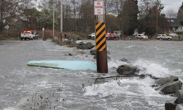
But earlier this week, a king tide combined with high winds and low barometric pressure made for one of the most tempestuous mornings those on the waterfront can remember. As Monday morning’s predicted 13-foot tide rose even higher and was bolstered by strong winds, seawater bashed docks and bulkheads, closed roads and swept away boats and dinghies all around Vashon.
“I’m virtually sure this is a record height,” said Bruce Morser, a longtime Islander who bundled up and came out with a couple of friends Monday morning to survey Quartermaster Drive, which was inundated by 8 a.m.
It’s hardly the first time the road has flooded, Islanders said, but it was one of the first times it was completely closed to traffic. As the waters rose, a green dinghy floated into the street and a sailboat that broke loose in the storm floated dangerously close to a waterfront home. Several emergency vehicles with lights flashing waited nearby, ready to respond should the situation worsen.
Down the road, Kevin Pottinger, who lives near Portage, waded in rubber boots
into the flooded street in front of his driveway. His 8-year-old son Alec watched from the side of the road.
“This is the worst we’ve seen it,” said Pottinger, whose family has lived there about a decade.
While the Pottingers sometimes brave the king tide waters in their minivan, this morning, he said, they couldn’t make it out of the driveway, and their children missed the first part of school.
“This is the first time we’ve not been able to go anywhere” because of a high tide, he said.
“It’s amazing what Mother Nature can do,” he added.
Governor’s Lane was a similar sight to behold. The high tide and crashing waves left the small road and its bordering yards full of driftwood and debris — so much so that the King County Roads Division quickly sent a bulldozer to clear the lane.
“It’s quite a mess,” said Will North, who lives on the road. He and some friends spent a couple of hours that morning clearing driftwood from around his home.
North said the water was “without a doubt” the highest he’d ever seen. The storm even sent seawater into his home’s foundation.
“It really stank during the middle of the day of seawater; the smell came up through the floorboards,” he said with a chuckle.
On the other side of the Island, wonder over the storm turned into dismay as residents of Sylvan Beach, a walk-in community, were trapped for a time by a high tide and waves that crashed over the boardwalk that runs in front of their homes. To make matters worse, a water main along the boardwalk broke, leaving the neighborhood without water until it could be repaired.
As the tides waned, Sylvan residents Sue Weston and John Montecucco emerged from their homes to asses the storm’s damage.
The boardwalk, which tops a long concrete bulkhead, was in shambles with boards washed out every few yards. Several docks had fallen victim to the waves, and a few dinghies were also missing in action.
“It’s a total wreck,” said Weston, who has lived at the beach for decades and couldn’t remember another storm this bad.
As the pair came to Montecucco’s home, the boardwalk was barely passable — concrete lay in crumbles, boards were mostly gone, and utility lines were exposed underneath. Montecucco, who has lived there half-a-dozen years, said he’d gotten up at 3 a.m. to secure his small boat. As for the bulkhead, he said, it would be up to the homeowners to repair.
“We’ll figure it out,” he said with a sigh.
Meanwhile, Rod Hearne and his son, who have a family home at Sylvan, came by searching for their lost dinghy. With Montecucco’s help, the pair found their boat submerged under a dock farther down the beach and pulled it onto the bulkhead. It bore a new hole in its hull.
“This is the worst it’s been in my lifetime,” said the elder Hearne. He added that he couldn’t help but wonder if climate change is a factor in the record high waters.
“It’s an act of nature,” he said with wide eyes.
Though king tides seldom do the kind of damage seen on Monday, local experts believe the extreme high tides are an indicator of what is to come, suggesting the new height waterlines might regularly reach as ocean levels rise due to climate change.
“It gives folks a glimpse of how, if sea water rises, it might affect the coast and marine regions all over,” said Curt Hart, a spokesman for the state Department of Ecology.
Along that vein, the state is asking those on the shore during king tides to snap photos and submit them online. The pictures are being used to track what tides are doing around Puget Sound and along the Washington coast and could help inform the state’s public outreach around climate change and its potential effects.
“That gives people a tangible thing to compare. Looking at these super-high tides, that could be the new normal,” Hart said.
Since the Washington King Tide Photo Initiative began in 2010, the state has collected hundreds of photos of extreme-high tides, though none from Vashon. Experts warn that Vashon, along with communities all over the Puget Sound region, should start thinking about the possibility of rising waters.
According to a recent climate change study by the National Academy of Sciences’ Division of Earth & Life Studies, global sea levels are expect to rise 3 to 9 inches by 2030, as much as 19 inches by 2050 and as much as 4-and-a-half feet by 2100.
Ellen Call, who lives with her husband on a beach near Cedarhurst Road, said she sometimes wonders about the effect climate change may have on Vashon. Five years ago, Call said, a wintertime king tide flooded the couple’s basement. Workers spent about an hour removing the water, and ever since she gets nervous during storms.
This Monday, the water was higher than Call had ever seen it.
“It looks like it’s a new mark, and maybe a new era,” she said.
King tides next month will be Jan. 14 at about 7 a.m., Jan. 15at about 7:45 a.m. and Jan. 16 at about 8:15 a.m.
Photos of king tides can be submitted to the Washington King Tides Photo Initiative Flickr group at www.flickr.com/groups/1611274@N22/. Note the date, time and location of the photo. Ideal photos are ones where water levels can be gauged against familiar landmarks.
Slideshow photo credits (in order): First seven photos of Quartermaster Drive and bay by Leslie Brown; photo of truck in water by Brian Brenno; six photos of Sylvan Beach by Natalie Johnson; one photo of a ping pong table in the water by Colin Ray; one photo of Maury Island Regional Marine Park by Ralph Moore; two photos of KVI Beach by Bruce Morser.
